Why I began this investigation
In all the years I lived in the Kemerovo Region, I could not think of a single river or other body of water about which I could say with confidence: the water here has not been affected by the coal industry.
In some places, the problem was almost literally visible. Signs beside certain bodies of water warned people not to swim. Elsewhere, the pollution was less obvious, but opening the annual reports of Rospotrebnadzor, Russia’s consumer health authority, and looking at the water test results raised more and more questions.
As I read those annual reports, I repeatedly found records of water samples that failed to meet sanitary standards. Yet during this investigation it became clear that results from different years cannot simply be combined into a single graph of continuous deterioration. The bodies of water examined, sampling points, number of samples, parameters tested and monitoring programmes all changed. The documents confirm that water-quality problems were recorded. They do not provide a simple, continuous data series for every river in the region.
For me, there has always been a terrible contradiction in this.
Kuzbass is rich in rivers, streams, springs and other bodies of water. Water is everywhere. Yet in some places people are advised not to use it, and in others doing so may simply be dangerous.
Water for people is at least treated. It passes through intakes, municipal utilities, purification and disinfection systems.
But what happens to all other life?
Trees cannot be connected to the water mains. Wild animals and birds drink from rivers, streams and puddles exactly as they find them. Fish live directly in that water — if they can live in it at all. Fish kills in Kuzbass were neither unimaginable nor unheard of to me.
At some point, simply seeing all of this around me was no longer enough.
I decided to examine the documents myself and find out what happens to our rivers and streams near coal-mining operations. I wanted to look beyond whether water becomes polluted after a discharge. My question was broader: what happens to the body of water itself when a vast open-pit mine appears nearby, groundwater is pumped out, the terrain is reshaped, waste dumps are built, and channels are diverted or blocked?
That is how this investigation began.
I wanted to understand and show another part of the real price of coal.
Coal is often described as a cheap fuel or a cheap source of energy. But if extracting it can pollute water, alter the movement of groundwater, reshape catchments, block streams and leave consequences for many years, a simple question arises: are we really calculating its price correctly?
Because people can live without coal.
Without clean water, they cannot.
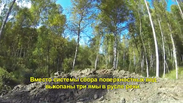
A stream whose channel ended up beneath a waste dump
In a ruling concerning the Kiyzassky open-pit mine, I found a description to which I returned repeatedly: the inspection materials referred to a temporary watercourse whose channel lay beneath an overburden dump.
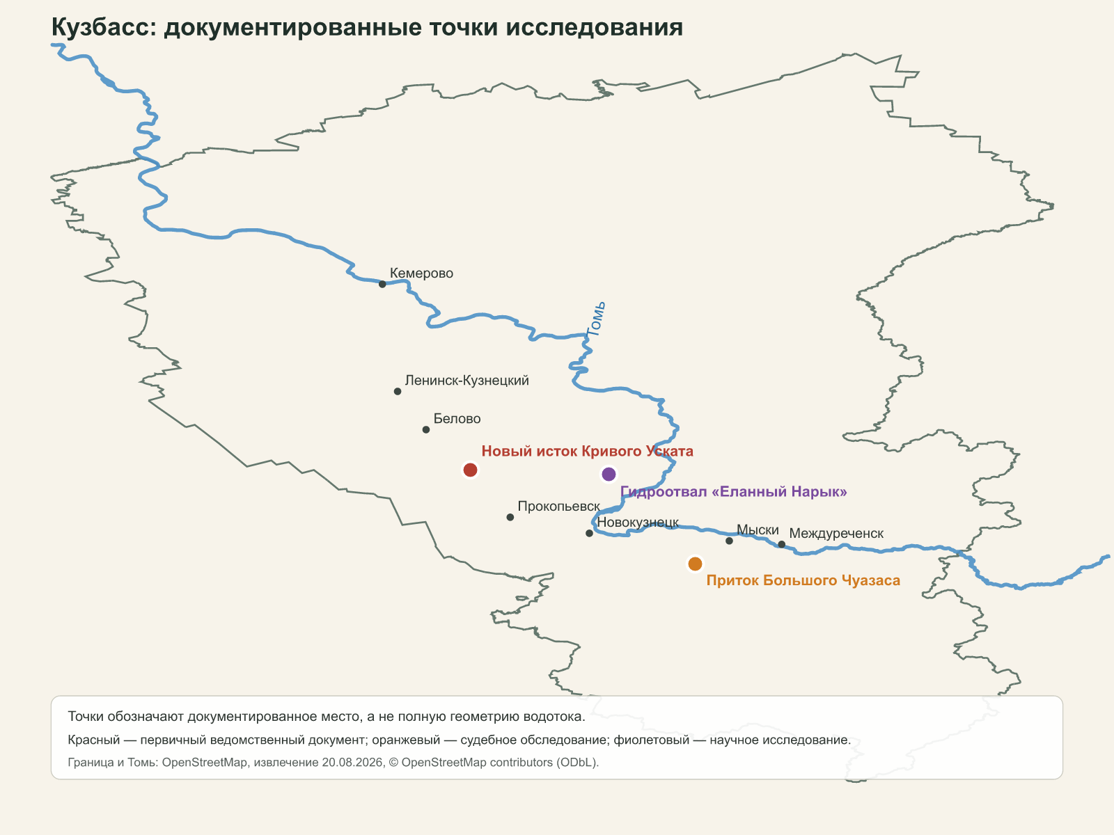
On 26 October 2018, a forested area beside the Severo-Zapadny external overburden dump was inspected. The inspection record described three pits dug along the stream’s former channel. The court noted separately, however, that no water was recorded during the inspection and that the materials did not confirm the existence of a stream flowing out from beneath the dump. An engineering organisation identified the former watercourse as a left tributary of the Bolshoy Chuazas that had been affected by human activity. The location coordinates and inspection details were later included in a ruling by the Myski City Court.1
The same ruling reproduced the substance of the project decision: building the dump on the site of the temporary watercourse involved filling the stream with overburden.
What exactly happened to the stream after it was filled? The ruling records the project decision and the condition of the site, but it does not confirm the presence of flowing water during the inspection. These materials do not establish whether the body of water persisted beneath the rock or ceased to exist.
The story also has an important legal conclusion. Proceedings in the specific administrative case were discontinued: the court found it unproven that the person charged had dug the pits and carried out the alleged use of the body of water without the required authorisation.1
It matters to me not to connect what the court did not connect. The ruling does not erase the physical condition of the site described within it. But the physical alteration itself does not establish the guilt of a particular person. A project decision, an observed condition, causation and legal responsibility each require different evidence.
Tributary of the Bolshoy Chuazas
The court ruling reproduces the project’s provision for placing the dump on the site of the stream.
No water was recorded during the inspection; a stream flowing out from beneath the dump was not confirmed.
The physical condition of the site and legal responsibility require different evidence.
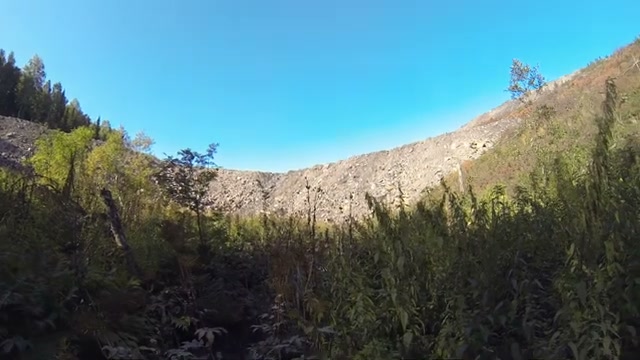
A river is more than the water we can see
At first I did not understand: if an open-pit mine is not located directly in a channel, why should water disappear from a stream? To answer that question, I had to look not only at the river but beneath the ground.
A stream is fed by more than surface runoff. Some rain and melting snow seep into the ground and recharge groundwater. That water emerges through springs and sustains streamflow during dry periods.
When coal is extracted below the groundwater level, water is pumped from the open pit or mine. This can create an area of lowered groundwater around the workings — a cone of depression. Its extent depends on the depth of mining, the volume pumped and the geology.
If the cone reaches the layer that feeds a spring or stream, the flow may decrease. A perennial watercourse may become seasonal, and part of its channel may dry out.
Surface runoff changes as well. Open pits, roads and ditches intercept water, while waste dumps create new terrain. Water that once drained into one stream may instead enter the pit, another catchment or a drainage system.
The reverse can also occur. Once pumped water has been treated, it may be discharged elsewhere, creating an additional human-made flow. When dewatering stops, groundwater may rise again and cause flooding.
These are possible mechanisms, not a ready-made explanation for every dry stream. A specific case requires groundwater levels, flow measurements before and after mining, geological data and consideration of other causes — from drought and water abstraction to construction.
How coal mining can change a small river
Some water runs off at the surface; some seeps underground and sustains springs and streams.
Continuous pumping can lower groundwater levels around the workings.
Open pits, roads, ditches and waste dumps can redistribute surface water.
Streamflow may fall, become seasonal, or the channel may change.
What does it mean for a river to “disappear”?
The more documents I read, the less comfortable I became with the word “disappeared”. In different records, it concealed entirely different events.
A watercourse may have ceased to exist. Its natural channel may have been filled, blocked by a dam or a mass of rock, or diverted into an artificial channel. Its source or catchment may have changed. Perennial flow may have become seasonal. Finally, a name or entry may have disappeared from a register or modern map even though water remains on the ground.
Pollution is a separate question. A river can be polluted and continue to exist. A channel can be physically altered even where data on the chemical composition of the water are insufficient.
For that reason, I try below to describe each event exactly as it appears in the documents: a watercourse ceased to exist, was blocked, filled or diverted; its source or catchment changed. I use the word “disappeared” only where the evidence truly supports it.
Krivoy Uskat: rivers that “ceased to exist”
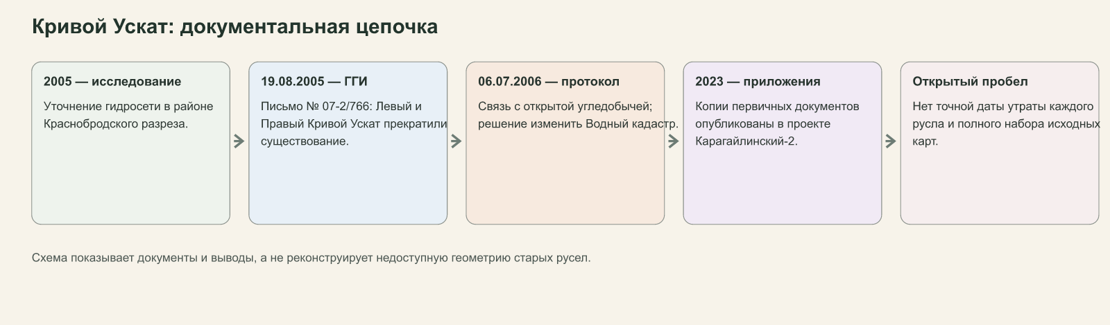
The strongest documentary chain I found concerned the upper reaches of the Krivoy Uskat near the Krasnobrodsky open-pit mine.
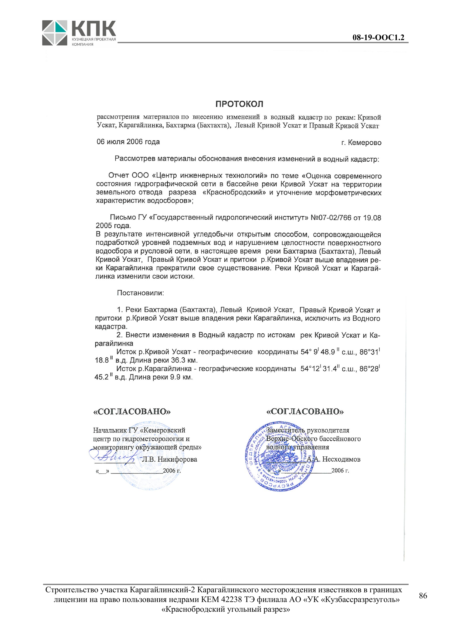
Appendices to the project documentation for the Karagailinsky-2 site preserve copies of three documents from 2005–2006: the conclusion of a study refining the hydrographic network, a letter from the State Hydrological Institute and a record of the materials’ consideration by the relevant authorities.2
Letter No. 07-2/766 from the State Hydrological Institute, dated 19 August 2005, states:
“The Left and Right Krivoy Uskat rivers have ceased to exist.”
It also says that the Bakhtarma and the tributaries of the Krivoy Uskat from its headwaters to the confluence with the Karagaylinka had ceased to exist completely. According to the document, the present-day Krivoy Uskat now began at a pond 2.7 kilometres upstream from the mouth of the Karagaylinka.
On 6 July 2006, representatives of the regional hydrometeorological service and the Upper Ob Basin Water Administration considered the materials. Their record linked the transformation of the area to intensive open-pit coal mining, the lowering of groundwater levels and disruption of the integrity of the surface catchment and channel network.2
The record called for the listed watercourses to be removed from the State Water Cadastre and for the information about the sources of the Krivoy Uskat and Karagaylinka to be amended. It gave coordinates for the new source of the Krivoy Uskat and a new river length of 36.3 kilometres.
This was the first time I encountered not a journalist’s assessment or someone’s recollection, but an official acknowledgement that named watercourses had ceased to exist. A specialist scientific institution recorded it in writing, and government bodies approved the change to the cadastral description of the hydrographic network.
Even this strong set of documents does not answer every question. It does not provide the exact year in which each channel was lost or establish with certainty which changes occurred after the start of 2000 and which may have happened earlier. The available materials do not contain a complete set of old maps and field measurements. They explicitly link the overall transformation of the area to open-pit coal mining, but do not apportion the contribution or legal responsibility of individual companies.
The central fact is nevertheless established: some elements of the hydrographic network did not merely become dirtier or shallower. They were officially recognised as having ceased to exist, and the description of the river sources had to be changed.
Krivoy Uskat: the institute letter and the approved record
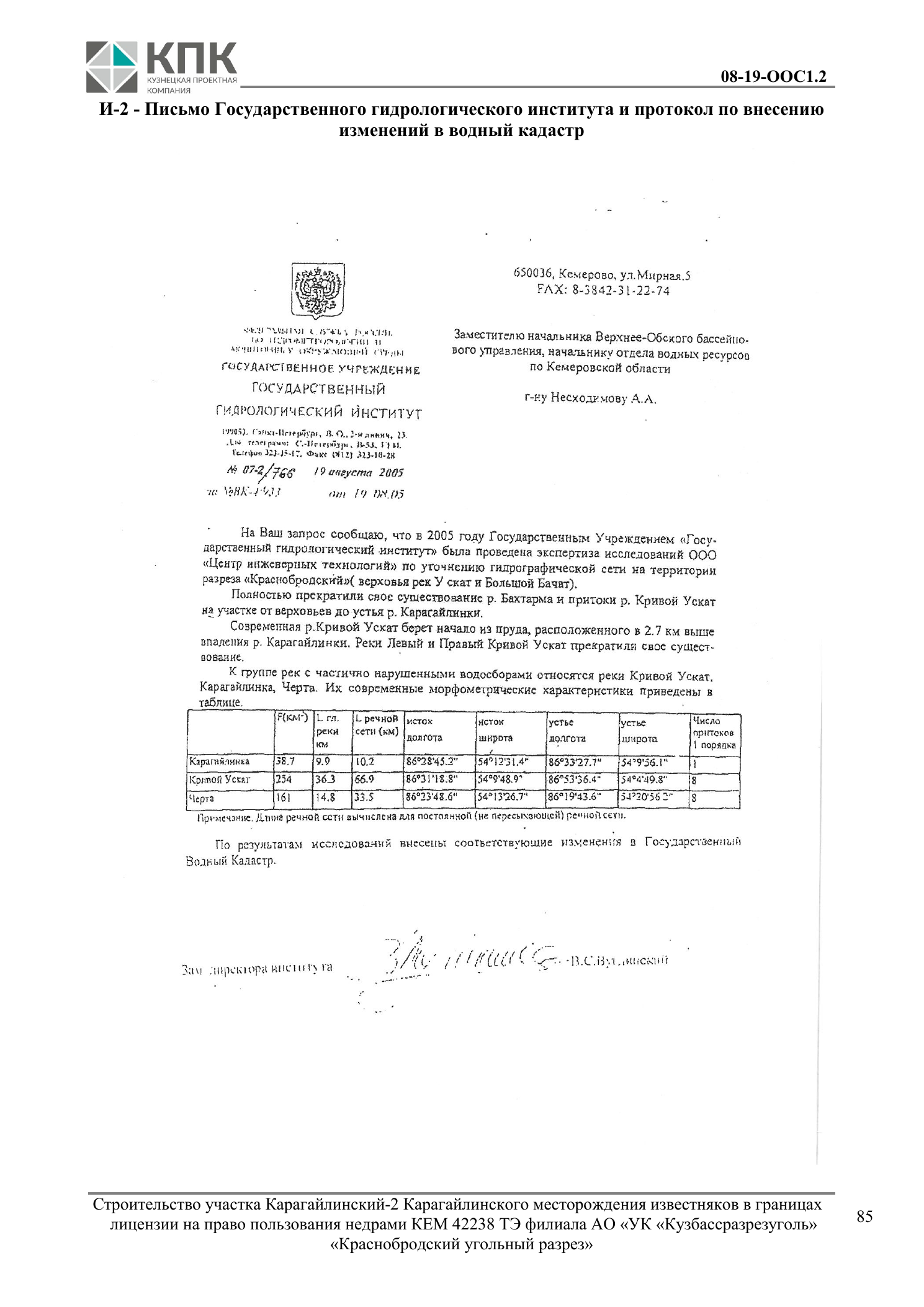
“The Left and Right Krivoy Uskat rivers have ceased to exist.”
When a river becomes part of an industrial structure
The Yelanny Naryk illustrates a different kind of transformation. The river is not described as having disappeared, but its channel became part of an industrial structure.
At the Taldinsky open-pit coal mine, a hydraulic fill dump was built on the river of the same name — a structure into which overburden was carried together with water. According to a scientific study, two dams were built across the valley and blocked the channel. Construction was completed in 1996; operation began in 1997 and continued through the 2013 deposition season.3
An industry publication mentions a pumping station that carried floodwater beyond the hydraulic fill dump and returned it to the Yelanny Naryk.4
The documents confirm that the natural channel was blocked by dams and incorporated into a technological system. Water continued to move, but through an engineered system. I cannot call this the river’s complete disappearance: the documents make no such finding.
I was unable to establish the flow before construction, how water was conveyed throughout the years of operation, or the condition of the river by 2022. The Yelanny Naryk is therefore not another entry in a list of vanished rivers, but a distinct example of a channel incorporated into an industrial system.
A brief comparison: the Kyrgay. Two consistent reports from 2014 described the diversion of the Kyrgay River, which crossed the site of the future Kyrgaysky Sredny open-pit mine. VSE42 added that the water had been directed through an artificial channel.5 The primary project file, permit, completion record and flow measurements before and after the work were not found. The Kyrgay therefore illustrates a possible channel diversion, but does not prove that the water disappeared or the flow ceased.
Yelanny Naryk: what is established and what is not
- the hydraulic fill dump’s dams crossed the valley and blocked the channel;
- operation began in 1997;
- a pumping system returning floodwater to the Yelanny Naryk was described.
- the river’s complete disappearance;
- comparable flow measurements before and after construction;
- the condition of the watercourse after deposition ended.
The Kiyzas area: several rivers and several different events
I confused them myself more than once. The names are similar, the area is the same, and the documents sit alongside one another. It is very easy to turn several different events into a single story. I therefore separated the tributary of the Bolshoy Chuazas, the Bolshoy Chuazas itself and the Bolshoy Kiyzas.
Tributary of the Bolshoy Chuazas
This is where the article began. For the temporary stream, the planned filling and the site’s condition in October 2018 are documented: the inspection record described three pits along the former channel, but no water was recorded during the inspection. The court did not identify the perpetrator of the specific violation.
The Bolshoy Chuazas and the drainage system
The court ruling records authorised wastewater outlet No. 1 into the Bolshoy Chuazas and gives the details of the relevant water-use permit.1 Archive footage from the same industrial area shows a pipe, a flume and disturbed forest land. But without an as-built diagram, an individual pipe in a photograph cannot be identified as the specific documented outlet, and the chemical composition of the water cannot be determined by appearance.
Procurement procedures from 2019 and 2022 confirm an intention to commission the development and revision of a project to divert or straighten the channel of the Bolshoy Chuazas. The 2022 procedure was cancelled without a contractor being selected; it was not possible to establish whether the design work or any subsequent works were carried out.18
The Bolshoy Kiyzas and the 2019 landslide
In June 2019, a mass of rock slid from the mine’s external dump and blocked the channel of the Bolshoy Kiyzas. Official and media reports estimated the affected stretch at approximately 700–800 metres.6
After the event, reports described the reclamation of disturbed land, grading of displaced rock, dredging and other work involving the channel and banks, as well as compensatory measures.7
The consequences later became the subject of court action. However, the collected material does not contain the complete primary case concerning harm to the body of water or a single final acceptance certificate for the restored channel. I can therefore speak with confidence about the landslide, the blockage of the channel and the official response that followed, but not about the complete remediation of the consequences.
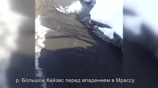
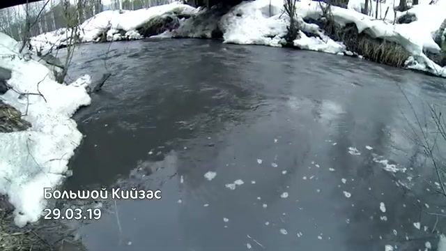
An archive image of the Bolshoy Kiyzas dated 29 March 2019 shows the river near its mouth before it enters the Mras-Su. It was taken about two months before the landslide, but the precise relationship between the location shown and the area later blocked has not been established.
This separation may seem excessive only until the Bolshoy Chuazas, its unnamed tributary and the Bolshoy Kiyzas begin to be treated as the same river and one continuous causal story. The documents do not permit that.
The Kiyzas area
Planned filling of a temporary watercourse, inspection of the former channel and the limit of the court’s finding.
Procurement procedures for a diversion or straightening project; the procedures do not prove that the work was carried out.
A rockslide, blockage of the channel and reports of restoration measures.
What the project designers knew in advance
I wanted to understand whether such changes came as a surprise. To do so, I turned to environmental impact assessment materials, known in Russian as OVOS. They are prepared before project decisions are adopted or implemented and describe the baseline condition of the area, possible consequences and monitoring measures.
An environmental impact assessment is not evidence that a forecast came true. But it shows that the risk was known before the work began or expanded.
The assessment for the Raspadsky IX–XI and Dorozhny sites considered the partial or complete disappearance of small watercourses, the cessation of flow and the reshaping of channels. It named the Usa, Olzheras and their tributaries within the project area. The document provided for monitoring wells and checks on groundwater levels and chemical composition.8
The assessment for the Mrassky complex stated that the natural groundwater regime had already been disturbed by the long-term operation of several companies and that their cones of depression were developing together. It referred to 2005 monitoring programmes and two observation wells installed in 2011 towards the Kiyzas valley.9
For the main field of the Mezhdurechensky open-pit mine, the project model estimated the area affected by drainage and provided for regular level measurements, more frequent monitoring during floods, and chemical sampling during both floods and summer low-flow periods.10
The 2013 Kiyzassky environmental assessment classified disruption of the catchment area and channel regime, with the loss of small rivers and streams, as a significant impact.11
Behind the technical language, a simple sequence emerges:
- the project describes in advance a possible change to a channel, flow or groundwater supply;
- the project provides for monitoring;
- mining begins or continues;
- years pass;
- verifying the outcome requires a comparable data series for the same body of water.
It is often at this final step that the open chain of evidence breaks.
Four project documents
Raspadsky IX–XI and Dorozhny
- Forecast
- Changes to the river network, partial or complete disappearance of watercourses, cessation of natural flow.
- Monitoring
- Groundwater levels and chemistry, condition of receiving waters.
- Later
- No comparable open data series for the same objects was found.
Mrassky complex
- Forecast
- Disruption of the natural regime, merging cones of depression, interception and redistribution of runoff.
- Monitoring
- Wells, water levels, flood observations and chemical composition.
- Later
- No public follow-up tables from the programme were found.
Main field of the Mezhdurechensky mine
- Forecast
- Development of a cone of depression and drainage of aquifers.
- Monitoring
- Existing and planned wells, water levels, chemical composition and an annual assessment.
- Later
- No public sequence of annual results was found.
Kiyzassky
- Forecast
- Disruption of the catchment area and channel regime, with loss of small rivers and streams.
- Monitoring
- Environmental controls provided for in the project.
- Later
- Separate materials exist, but no single series links baseline condition, forecast and outcome.
The forecast survived. Where is the outcome?
Here I encountered something I had not initially expected: a document describing what might happen to a river in ten years can sometimes be easier to find than a document describing what actually happened to it over those ten years.
A project document may survive for many years. It sets out risks, calculated levels, wells and a monitoring programme in detail. But I was interested in the next, very simple question: did the forecast come true? Open information about the condition of a specific river after the work began is much harder to find.
If I did not find results in open sources, that does not mean monitoring never took place. Companies may have kept logs, collected samples and submitted reports to government bodies. But without accessible results, it is impossible to trace independently the entire path from forecast to actual condition.
What was the river like before the work? Where were the monitoring points? Did the level and flow change? Did the spring survive? Was the channel diverted? What happened five or ten years later?
For pollution in an existing river, a sample can be taken upstream and downstream of an outlet. When the river itself changes, far more must be preserved: the old channel geometry, baseline flow, links to groundwater, the position of the source, catchment boundaries and the history of subsequent changes.
If an unnamed stream had no separate register entry, an old monitoring point vanished when its channel was diverted, and operational monitoring results are unavailable, reconstructing what happened becomes much more difficult as the years pass.
I cannot call this evidence of deliberate concealment. Yet the gap remains: environmental oversight is better equipped to measure the parameters of an existing object than to preserve the continuous history of an object that has been physically altered.
Discharge ≠ sample ≠ the river’s physical condition
I genuinely thought I would find this connection. I did not.
At the start of the investigation, I assumed that physical changes to the hydrographic network might affect the official picture of polluted wastewater. The evidence forced me to abandon the stronger version of that hypothesis.
Official water-discharge data show how much water a company discharged and how it was classified.
A laboratory sample shows what was present in the water at a particular place and time.
The physical condition of the hydrographic network answers a different question: do the channel, source, flow, catchment and groundwater supply still exist?
Closing a hydrochemical monitoring station or losing a stream does not automatically reduce the statistical volume of polluted wastewater. For that to happen, the outlet, volume, discharge method, receiving body, group of reporting organisations or quality category would have to change.
In the official series for 2011–2022, the volume of water classified as polluted fell substantially, while the volume of water classified as treated to standard increased.17 This is more consistent with the construction of treatment plants, water reuse and possible changes in classification than with the simple explanation “the rivers disappeared, so the discharges disappeared too”.
Without companies’ primary reporting forms, it is impossible to distinguish precisely between genuine improvements in treatment, reclassification and changes in the reporting perimeter. But the available series does not support my original strong hypothesis that the disappearance of watercourses directly affected the regional discharge indicator.
The same limitation applies to sanitary data. For example, the available official material records 433 sanitary-chemical and 904 microbiological samples from category-one bodies of water in 2016, and 348 and 980 respectively in 2019.12 But the sampling points, bodies examined and parameters tested may have changed between years. These figures describe specific monitoring programmes, not the proportion of polluted rivers across the entire region.
A good sample from an existing monitoring section says nothing about a stream that is no longer included in the monitoring programme. Conversely, the physical disappearance of a stream does not prove a reduction in the official volume of discharge.
Discharge≠Sample≠Physical condition
How much water was released, and how was it classified?
What was in the water at a specific point and moment?
Do the channel, source, flow, catchment and groundwater supply still exist?
Why I do not write that 200 rivers have disappeared in Kuzbass
In 2007, the newspaper Argumenty i Fakty — Kuzbass wrote of approximately 200 streams having disappeared and the hydrographic network shrinking by 15 kilometres a year.13
I wanted that figure to be real. It corresponded too closely to what I had seen myself. That was precisely why it had to be checked especially rigorously.
The search led to Galina Falkova’s 2005 study. The available wording says that in the mining zone, “more than 200 streams disappeared or became shorter”.14
This is a compound statement: it combines complete disappearance with a reduction in length. In later citations, the wording became more categorical. An industry publication referred to around 200 vanished streams and a 365-kilometre reduction in the network.15 Another academic publication repeated those figures but did not identify their primary source in its bibliography.16
I could not find a list of the rivers, the underlying maps, the exact period or a reproducible method. Nor could I reconstruct the origin of the figure of 15 kilometres per year.
I therefore do not use 200 as a proven total. I am not dismissing the problem. I am rejecting a figure I cannot reproduce.
After this check, I kept one simple rule for myself: evidence that conveniently supports my hypothesis must be examined just as rigorously as a document that contradicts it.
What I can say after this investigation
I began with a sense that the coal industry had changed the water around me far more profoundly than ordinary pollution statistics revealed.
The documents confirmed part of that impression.
Some named watercourses in Kuzbass were officially recognised as having ceased to exist. Some channels were blocked by engineering structures, planned for filling or diversion. Project designers had considered in advance the risk that flow would cease, small watercourses and springs would disappear, channels would change and cones of depression would develop.
But I cannot give a total number of rivers and streams lost in Kuzbass. I cannot claim that every forecast in the environmental assessments came true. I cannot explain every dry stream through mine dewatering alone, or automatically assign legal responsibility to a company because an open-pit mine is located near a damaged channel.
I also had to abandon an explanation that initially seemed possible: the available data do not show that the reduction in the regional volume of polluted wastewater was materially caused by the disappearance of watercourses or the closure of monitoring stations.
The result is not one large number, but several precisely documented events and a boundary beyond which the data remain insufficient. To me, that is not a weakness of the investigation. It is its honest result.
A river can disappear twice
At first, I thought the central question of this investigation was how polluted the rivers and streams of Kuzbass had become.
Now I think there is another question: what happens to environmental oversight when industry changes the very object being monitored?
We know how to measure the concentration of a substance in an existing river and the volume of water at an existing outlet. But if the source has moved, the channel has been filled or diverted, the catchment has been reshaped, and the stream has ceased to exist as a separate object, one sample is no longer enough.
Old maps, baseline flow measurements, groundwater levels, the project forecast, monitoring points, the work actually carried out and the subsequent condition all need to be preserved.
Without that history, a river can disappear twice.
First, physically, when its channel, water supply, source or catchment changes.
Then from our ability to prove what it once was, what the project promised and what actually happened after the work began.
To me, the real price of coal includes more than the cost of extraction, electricity or treatment facilities. It includes rivers, streams and springs whose fate can no longer always be fully reconstructed. It includes life that cannot be connected to the water mains and must exist in whatever environment remains.
Protecting water begins with more than analysing its chemical composition.
It requires preserving the history of the body of water itself — before industrial impact, during the work and afterwards.